I know some of us were surprised to see a closed sign across the Rock Island from Highway 2 to 16th and Old Cheney. The closure will be in effect through Friday. Recommended detours are the Old Cheney and Tierra Williamsburg Trails.
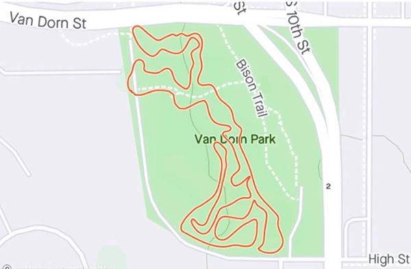
A new opportunity to try is the two mile mountain bike trail at Van Dorn Park. Dedicated volunteers have been busy the past two weekends putting it in, and now it needs some tire tracks on it. Read about it at https://journalstar.com/lifestyles/recreation/mountain-bike-trail-to-give-new-life-to-one-of-lincolns-older-parks/article.
It seems I’ve seen an uptick in mountain biking this summer. The trail at Branched Oak area 7 has gotten attention, and the southernmost loop in Wilderness Park is accessible once more from the Jamaica North since the bridge is open north of Saltillo.
On a recent ride out to Platte River State Park, I noticed more riders than I’ve seen in the past, and more are bringing their kids along. With the recent expansion on the east side of the park, bikers and horseback riders no longer have to share trails. Bikers don’t have to be off of them from 9:00 AM to 4:00 PM for the horses, a real problem in the past. For more information about riding there check out http://magazine.outdoornebraska.gov/2020/06/platte-river-state-park-bike-trails/. If I want to mountain bike there however, I have to drive my bike there, as riding to and from doesn’t leave much left over for taking on the hills. It is a great ride out there though, and I’ve done it many times. From the end of the MoPac at Wabash, head north on gravel following the bicycle route signage to Alvo Road, 1/4 mile, where you’ll turn right. Continue one mile East to 334th St. then seven miles north to highway 66. Take a right and in about a mile you’ll turn into the park. The new entrance for the mountain bike trails addition is one mile east, on 358th St. If you turn left instead of right on highway 66, you’ll see the entrance to the Lied Pedestrian and Bicycle Bridge, in about a mile. It is still closed. The bidding for the reconstruction of the railing and re-building the access from the North/East side is happening now. Debris had to be cleared away and inspections had to happen before getting to this point. The word is that it’s supposed to be open for the Market-To-Market Relay, October 3.
You can still get to the other side of the Platte by continuing on the shoulder of highway 66 past the park East to highway 50. There is a shoulder, but it diminishes on the bridge over the railroad tracks in Louisville. Continue to the bridge over the Platte, then pick up the MoPac again. It continues north past Springfield to the Omaha National Cemetary on Schramm Road, about eight miles. If you turn left after the bridge, you’ll arrive at the MoPac parking lot in about 4 miles. Unfortunately the trail to the Lied bridge is closed from there, still completely obliterated from the flooding.
The proposed continuation of the MoPac from Wabash to the Lied Bridge is still a mystery, with public right-of-way at issue as far as I know. A cyclist I ran across Sunday on the ride back had ridden to Wabash, but wouldn’t consider trying the gravel roads past there. There is little traffic, I had none, so maybe the hills turned him off. Whatever the case don’t be afraid to try something new. If it’s too far, drive part way out. It will be worth it.